
 CelebYachts reportInvestigations
The 1938 hull and the satellite gap
A 218-nautical-mile transit across the central Mediterranean reveals how a Thornycroft-built yacht maintains a steady 11.3-knot average, constrained by…
By On the record · Sep 23, 2026 · Data from CelebYachts1
A vessel’s position is the boat’s, not the owner’s. Ownership is as reported, not certified.
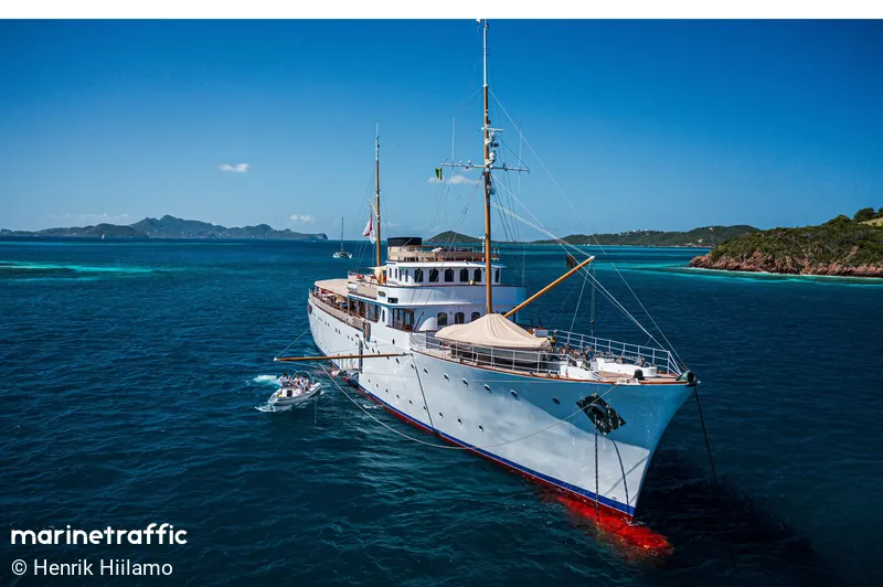
Shemara crossed from Sardinia to Mallorca in September 2026 at a constant speed, her track confirming that a 1938 hull form dictates a short-hop itinerary governed by mechanical reliability and satellite coverage limits.
The passage recorded as voyage 3340 demonstrates how a 1938-hull motor yacht navigates the central Mediterranean when forced into open water. Shemara departed the vicinity of Cagliari on 6 September 2026 at 13:33:36 UTC, positioned 41 nautical miles off the Sardinian coast at 39.09° N, 8.24° E. She arrived 61 nautical miles off Palma de Mallorca at 39.98° N, 3.83° E on 7 September at 09:24:48 UTC. The total distance covered was 218 nautical miles. Our receivers logged 203 nautical miles of her track. A gap of 15 nautical miles remains unobserved where the satellite constellation failed to capture her broadcast. The observed coverage stands at 93 per cent.

The Strait and the satellite gap
The track confirms a direct routing across the channel between Sardinia and the Balearic Islands. She maintained an average speed of 11.3 knots throughout the transit. Her maximum recorded speed was 12 knots. The consistency of these figures indicates that she did not alter course to avoid traffic or weather, nor did she reduce power to conserve fuel. A vessel of her generation operates at a fixed point in her performance envelope. The machinery runs at a steady load, and the hull plane settles into a predictable resistance curve. The 15-nautical-mile blind spot falls roughly mid-channel, beyond the range of terrestrial VHF repeaters and outside the densest satellite handover zones. The remaining 203 nautical miles, captured across 75 discrete position fixes, leave no ambiguity about her heading or her speed. She crossed the water at a constant rate.
The coastal circuit
The Cagliari-to-Palma run sits at the top of her recent movement log by distance alone. It is an outlier in a series of short hops that define her operational radius. Before leaving Sardinia, she executed a local maneuver on the same day. Passage 3320 began at Cagliari and ended 38 nautical miles off the coast, covering 18.7 nautical miles with 100 per cent AIS coverage. After reaching the waypoint off Mallorca, she completed passage 3415 from 61 nautical miles off Palma to the port itself, a distance of 32.8 nautical miles, again with full coverage. These two legs bracket the open-water crossing and highlight the difference between coastal tracking and satellite telemetry. Within sight of land, her transponder broadcasts are received continuously. Out at sea, the signal drops out, but the intervals between the last fix before the gap and the first fix after it confirm that she did not deviate.
Her movements prior to September follow the same pattern of restricted range. On 4 September, she moved from Reggio Calabria to Messina, Italy, covering 52.1 nautical miles with 76 per cent coverage. Earlier in the month, she operated entirely within Greek waters. On 28 August, she sailed from Lefkada to Igoumenitsa, Thesprotia, a distance of 46.0 nautical miles. Two days earlier, she made a short run from Palairos back to Palairos, covering 18.3 nautical miles. On 25 August, she looped near Patras, Achaea, traveling 12.6 nautical miles between positions 59 nautical miles and 50 nautical miles off the coast. On 24 August, she moved from Preveza in Epirus to Lefkada in the Ionian Islands, a distance of 26.1 nautical miles. On 20 August, she sailed from Igoumenitsa to Corfu, Ionian Islands, covering 23.1 nautical miles. On 16 August, she loitered near the Rio strait, moving just 6.4 nautical miles between positions 47 nautical miles and 42 nautical miles off Rio. On 14 August, she departed Lefkada and returned to Lefkada, covering 27.6 nautical miles.
Every leg in this sequence stays under 60 nautical miles. The longest previous run, Reggio Calabria to Messina, covers barely more than half the distance of the Sardinia-Mallorca transit. The pattern suggests a vessel that avoids extended periods away from established harbours. The AIS coverage percentages reinforce this habit. Legs conducted near the Greek coastline frequently hit 100 per cent coverage, sometimes with very short distances like the 6.4-nautical-mile loop off Rio or the 12.6-nautical-mile drift near Patras. The open-water crossings drop to 76 per cent or 93 per cent, reflecting the limitations of satellite reception rather than changes in her broadcasting equipment. She does not appear to switch off her transponder when leaving coastal range. The gaps are purely geometric.
The weight of 1938
The constraints on Shemara’s itinerary are physical, not regulatory. She is a 64.09-metre motor yacht built by John I. Thornycroft & Co. at their Woolston yard. Her keel was laid in 1938, and she flies the flag of the United Kingdom. Her gross tonnage registers at 859. These figures describe a hull designed for a different era of marine engineering. The gross tonnage measurement captures the total internal volume of the enclosed spaces, which in a vessel of this age correlates directly with displacement and structural weight. A 64-metre yacht carrying nearly 860 tons of gross register volume requires substantial machinery to maintain forward motion. The 11.3-knot average speed recorded during the Cagliari-Palma passage is consistent with the sustained output of a mid-20th-century diesel installation. Modern equivalents of similar length typically achieve higher cruising speeds with lower fuel consumption because their hull forms are optimized for planing or semi-planing modes. Shemara’s lines were drawn before computational fluid dynamics existed. She moves through the water by displacing it, and the resistance she encounters scales with the square of her speed.
The builder, John I. Thornycroft & Co., established a reputation for constructing fast naval vessels and luxury liners at Woolston on the River Itchen. The yard ceased commercial yacht construction decades ago, and the facility itself has been redeveloped. Shemara survives as a functioning example of that output. Maintaining a 1938 hull in seaworthy condition demands a schedule of dry-docking and mechanical overhaul that aligns with her age. The short-hop itinerary observed in August and September fits the maintenance cycle of a vessel that cannot afford to be stranded far from specialized repair facilities. A breakdown in the middle of the Aegean or the central Mediterranean would require towing, which poses risks to a hull of this vintage that modern composites do not face. The decision to remain within 60 nautical miles of Italian and Greek ports, punctuated by occasional longer crossings like the one to Mallorca, reflects a practical assessment of her mechanical reliability.
The owner, Sir Bernard Docker, acquired the vessel through standard private market channels. The registration lists him as the registered owner, though the corporate structures behind such acquisitions are rarely disclosed in public records. The flag state, the United Kingdom, imposes standard safety and crewing requirements under the Merchant Shipping Acts, but these regulations apply equally to new builds and historic vessels. They do not explain the specific routing patterns. The routing is explained by the interaction between her 1938 hull form, her 859 gross tonnage, and the 11.3-knot speed envelope that her engines sustain. She crosses the Mediterranean not because she can outrun weather fronts, but because she can maintain a steady pace over short distances without risking the mechanical integrity that keeps her afloat.
Reporting and data: CelebYachts, republished by On the record.
Sources
The numbers on this page point here. Each one links to the record it came from.
- 1