
 CelebYachts reportData
The crossing from Reggio Calabria to Zakynthos
A 243-nautical-mile passage across the Ionian Sea reveals how a 1981 Niarchos yacht balances speed and signal coverage when leaving the Italian coastal circuit.
By On the record · Sep 30, 2026 · Data from CelebYachts1
A vessel’s position is the boat’s, not the owner’s. Ownership is as reported, not certified.
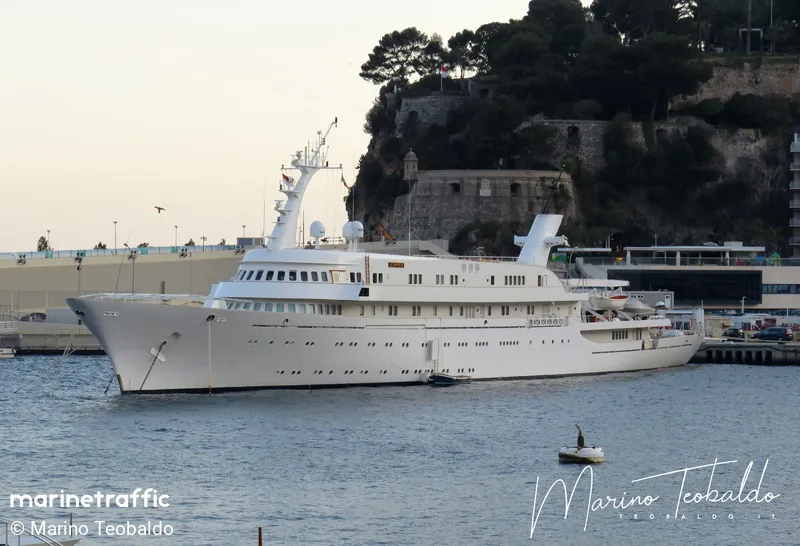
Leaving the congested waters of the Tyrrhenian coast for the open Ionian basin, Atlantis II maintained a steady 13.7 knots over 17 hours. The drop in AIS coverage to 95 per cent and the sustained power output mark a distinct operational shift for the 115-metre Hellenic Shipyards vessel.
The passage recorded between 7 and 8 August 2026 charts a deliberate departure from the protected waters of the Tyrrhenian coast. Atlantis II cast off from Reggio Calabria at 12:47 local time and made fast at Zakynthos nearly seventeen hours later. The vessel covered 243 nautical miles across the open Ionian basin, sustaining an average speed of 13.7 knots. This run represents a clear operational break from the preceding week, during which the 115-metre Niarchos family yacht remained entirely within the range of terrestrial AIS transponders. The drop in signal coverage to 95 per cent and the continuous power application required to maintain her cruise speed highlight the physical constraints of a displacement hull built in 1981.
The coastal circuit
For the six days leading up to the crossing, Atlantis II operated almost exclusively along the Italian shoreline. The AIS log records a sequence of short, fully tracked hops that kept the vessel within reliable radio range. On 1 August she moved from Monaco to Genoa, covering 87 nautical miles. Two days later she proceeded from Genoa to Civitavecchia, a distance of 155 nautical miles. She then ran south to Naples, logging 170 nautical miles with perfect coverage. By 5 August she was conducting local manoeuvres between Capri and Sorrento, a mere 7 nautical miles, before heading further south to Positano and finally reaching Reggio Calabria on 6 August. Each of these passages registered 100 per cent AIS coverage, indicating that the vessel never lost line-of-sight contact with the coastal receiver network.
The geometry of those movements traces a tight loop around the western Mediterranean littoral. The distances were manageable for a vessel of her size, but they also reflect a strategy of staying close to shore. Terrestrial AIS operates on VHF frequencies, which travel roughly 20 to 30 nautical miles depending on antenna height and atmospheric conditions. By remaining within that envelope, the operator ensured uninterrupted tracking. The decision to leave that environment on 7 August required accepting a loss of signal fidelity. As the yacht pushed westward from the Calabrian tip toward the Greek island of Zakynthos, she crossed the threshold where land-based receivers could no longer guarantee a fix.
The Ionian run
The track from Reggio Calabria begins at 37.99° N, 15.62° E and terminates at 37.78° N, 20.67° E. The direct line across the water measures 243 nautical miles. The actual distance logged by the AIS system was 229 nautical miles, showing a slight deviation from the great circle path, influenced by prevailing currents or minor course corrections to avoid traffic lanes. The passage lasted 16 hours and 38 minutes. During that time, the system recorded 24 position fixes. The maximum speed reached 16.2 knots, but the average held steady at 13.7 knots. That consistency suggests the engines were set to a specific cruising regime rather than being pushed for top speed.
The most notable feature of this leg is the 95 per cent coverage figure. The difference between the total distance and the observed distance amounts to 13 nautical miles where the track went dark. In a coastal hop, a gap of that size would be unusual, but over open water it is standard. Satellite AIS picks up the transmissions when terrestrial signals fade, but the update rate and positional accuracy differ. The 13 nautical mile blind spot falls squarely in the middle of the Ionian crossing, where the vessel was farthest from both the Italian and Greek coasts. The operator accepted this gap in exchange for the speed needed to cover the distance in a single night watch.

The displacement profile
Atlantis II is a product of early-1980s superyacht construction. Launched in 1981 by Hellenic Shipyards, she measures 115.82 metres in length and carries a gross tonnage of 3243. She flies the Bermudian flag. The combination of her length and tonnage places her firmly in the displacement category, meaning her theoretical hull speed is governed by the square root of her waterline length multiplied by 1.34. At 115 metres, that theoretical limit sits around 14.4 knots. Maintaining an average of 13.7 knots over 229 nautical miles requires keeping the vessel near that hydrodynamic ceiling for an extended period.
The power requirements for a hull of this era differ significantly from modern designs. Early-80s vessels typically relied on heavy-duty marine diesel engines that prioritised torque and reliability over fuel efficiency. Running at 13.7 knots for nearly seventeen hours demands a substantial fuel burn, yet the speed profile remains remarkably flat. There are no sudden spikes to 16 knots followed by long periods of idling. The consistent pace indicates a well-calibrated propulsion setup capable of sustaining high RPMs without overheating or suffering mechanical stress. The 16.2-knot maximum recorded during the passage confirms that the engines had reserve power available, but the skipper chose not to utilise it.
The route itself avoids the shallow waters of the northern Aegean, opting instead for the deeper channels of the central Ionian. This choice minimises the risk of grounding and allows the 115-metre hull to maintain her trim without adjusting for varying depths. The arrival at Zakynthos completes a circuit that began in the French Riviera and wound down the Italian peninsula. The vessel has now returned to the Greek islands, a region familiar to the Niarchos family fleet. The passage demonstrates how an older, heavier yacht manages open-water transit: by holding a steady speed, accepting occasional signal loss, and relying on proven mechanical endurance rather than digital connectivity.
Reporting and data: CelebYachts, republished by On the record.
Sources
The numbers on this page point here. Each one links to the record it came from.
- 1