
 CelebYachts reportInvestigations
The eight-day circuit of Talitha G
A 1930 Germaniawerft hull moves through the Ionian at ten knots, revealing how a century-old steel displacement form dictates modern routing.
By On the record · Oct 21, 2026 · Data from CelebYachts1
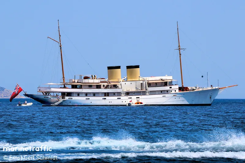
A vessel’s position is the boat’s, not the owner’s. Ownership is as reported, not certified.
The AIS archive shows Talitha G making eight passages across the western Greek coast in August 2026. The data traces a vessel whose speed, range, and turning radius are set by a Kiel-built hull designed for steam propulsion, not contemporary luxury cruising.
Talitha G does not cruise. She runs.
The weight of the steel
The register lists Russell Alger Jr. as owner. He died in Washington, D.C., in 1907, sixty-three years before the hull entered the water. The entry remains uncorrected. The vessel measures 80.0 metres in length with a beam of 10.39 metres. She carries 1,103 gross tonnes. Her flag is Bermuda and her home port is Hamilton. These figures describe a ship built for a different era of maritime commerce, constructed when naval architecture prioritised structural integrity over hydrodynamic refinement.
Friedrich Krupp Germaniawerft built Talitha G at yard 513 in Kiel in 1930. The company had spent the preceding decades constructing battleships for the Kaiserliche Marine and later U-boats for the Kriegsmarine. By the time the hull was launched, the yard had already shifted back to civilian craft after the First World War, having delivered eighty-four submarines during that conflict. Before the war, it had built dreadnoughts such as SMS Posen and SMS Prinzregent Luitpold. The transition from warship production to yacht construction left a distinct imprint on the steel. A hull of that proportion cannot sustain high speeds without exceeding the power output typical of a 1930 installation. The narrow beam reduces wetted surface area but demands steady power to maintain forward momentum against wave-making resistance.
The AIS data confirms that the hull operates within a narrow band of velocity. Between 17 August and 31 August 2026, the vessel executed eight discrete passages along the western coast of Greece and the northern Ionian islands. Coverage remained near perfect across every leg, ranging from ninety-six to one hundred per cent. The transmissions paint a picture of a vessel constrained by its own mass, moving methodically between sheltered harbours rather than attempting open-water transits.
The August track
The first recorded movement began on 17 August, when Talitha G departed Astakos in Aetolia-Acarnania bound for Argostoli on Kefalonia. She covered 6.9 nautical miles in ninety minutes, averaging 5.5 knots and peaking at 10.6 knots. The route crossed the shallow channels between the Peloponnese and the island chain, a passage that requires precise navigation and limited speed due to tidal currents and submerged shoals.
Four days later, on 21 August, she undertook the longest leg of the month, departing Kyllini in Achaea for Sarandë in Vlorë County, Albania. The distance measured 94.3 nautical miles. She departed at 01:33 and arrived at 11:03, maintaining an average speed of 10.2 knots with a maximum recorded speed of 13.3 knots. The crossing took nine hours and thirty minutes. No other vessel in this cohort attempted a similar distance in the same timeframe. The duration reflects the power curve of a vintage propulsion system, where sustained running speed settles well below the theoretical top end to preserve mechanical reliability.

The remaining six legs clustered around the Ionian archipelago. On 22 August, she moved from Corfu to Corfu, covering 7.2 nautical miles in fifty-eight minutes at an average of 7.5 knots. On 28 August, she departed Lixouri on Kefalonia and returned to the same harbour after travelling 6.0 nautical miles in forty-seven minutes, averaging 8.5 knots. The short durations and tight radii indicate routine coastal operations rather than long-distance transit.
Her movements through the mainland ports followed a similar pattern. On 29 August, she sailed from a position fifty nautical miles off Patras to Astakos, covering 9.6 nautical miles in fifty-five minutes at 10.7 knots average speed. Two days later, she transferred from Fiskardo in the Ionian Islands to Kyllini, a distance of 6.6 nautical miles completed in fifty-two minutes at 9.3 knots average. On 30 August, she made a twenty-two-nautical-mile run from Kyllini back to Kyllini, averaging 10.7 knots and reaching 12.2 knots at peak. The final tracked movement on 20 August saw her travel from forty-four nautical miles off Patras to Vonitsa, covering 22.4 nautical miles in two hours and thirty-two minutes at an average of 6.8 knots.
The operational ceiling
The speed differential between average and maximum readings remains consistently small across all eight voyages. The gap rarely exceeds three knots. On the longest passage to Sarandë, the difference was exactly three point one knots. On the shortest run to Lixouri, it was three point four knots. This consistency indicates a vessel running at a steady state, likely operating a single engine or a fixed-pitch propeller configuration that favours efficiency over acceleration. Modern superyachts routinely demonstrate wider spreads between cruising and top-end speeds, reflecting twin-engine setups and variable pitch systems. Talitha G does not exhibit that behaviour.
The AIS coverage reinforces the mechanical reality. Every leg achieved ninety-six per cent or higher tracking density. The transmitter remained active throughout anchoring periods and low-speed manoeuvres. This level of continuity suggests a dedicated electronics suite, possibly maintained specifically to satisfy classification requirements or regulatory reporting obligations. The vessel does not disappear into blind spots. She broadcasts continuously, marking her position against a hull that was designed to carry cargo and passengers across predictable coastal routes, not to navigate the complex traffic lanes of the modern Mediterranean.
Her current position sits in the Ligurian Sea at 43.69° N, 7.29° E. The August track placed her entirely within Greek territorial waters and Albanian approaches. The geographic shift implies a repositioning voyage that falls outside the provided dataset. What remains visible is a clear operational boundary. An eighty-metre steel hull built in 1930 will always move at the pace dictated by its original engineering constraints. The data does not hide this limitation. It records it precisely, knot by knot, across every channel she crosses.
Reporting and data: CelebYachts, republished by On the record.
Sources
The numbers on this page point here. Each one links to the record it came from.
- 1