
 CelebYachts reportData
The eight-hundred-mile month
A 2022 Silver Yachts hull logged nearly seven hundred nautical miles in August across the western Mediterranean, revealing a transit pattern dictated by harbour depth rather than owner preference.
By On the record · Oct 28, 2026 · Data from CelebYachts1
A vessel’s position is the boat’s, not the owner’s. Ownership is as reported, not certified.
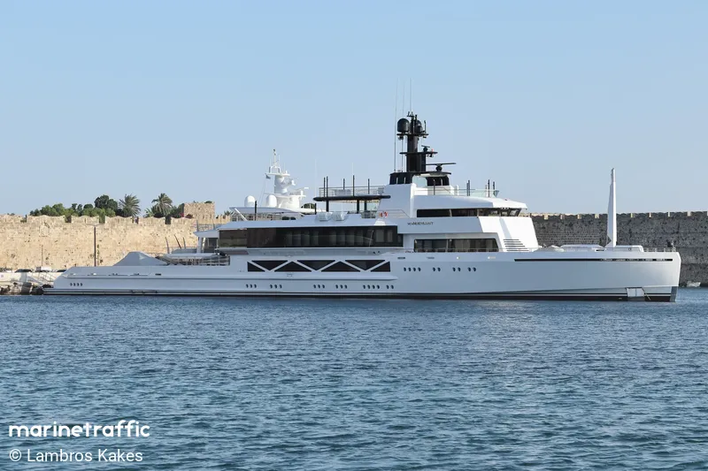
Wanderlust, an eighty-five-metre motor yacht registered in the Marshall Islands, spent August 2026 executing a series of short, high-speed passages between La Maddalena, Olbia, and the French Riviera. The AIS record shows a vessel optimised for open-water cruising rather than extended coastal loitering.
The hull known as Wanderlust entered the register in 2022. She was constructed at Silver Yachts in Henderson, Washington. The specifications place her at eighty-five metres in length and fourteen metres in beam. The gross tonnage registers at 1561. Her flag is the Marshall Islands, and her declared home port is Bikini. The estimated market value stands at one hundred million dollars. The registered owner is Yim Leak, a Cambodian national who serves as Chairman of BIC Group. His professional background spans Real estate development, banking, and investment. The capital that purchased the steel came from those sectors, and the resulting asset carries no visible concession to the owner's personal habits beyond the standard layout of an eighty-five-metre explorer.
The AIS archive provides a continuous track for exactly sixteen days in August 2026. Between the ninth and the twenty-fourth, Wanderlust executed eight separate passages. The total distance covered across those legs is six hundred and ninety-six nautical miles. The routing follows a tight corridor between the northern tip of Sardinia, the western coast of Corsica, and the eastern French Riviera. No position appears outside this triangle until the final broadcast, which placed her at forty-three point one two degrees north, five point five nine degrees east, off the Provencal coast. The concentration of movement indicates a vessel that uses the Mediterranean as a highway rather than a mooring.
The August transits
The first leg captured in the database runs from La Ciotat in southern France back to La Ciotat on 9 August. The vessel departed at 09:41 and returned at 15:56, covering eighty-eight point six nautical miles in six hours and fifteen minutes. She maintained an average speed of fifteen point one knots and peaked at fifteen point six knots. This figure establishes the baseline performance for open-water transit. An eighty-five-metre displacement hull typically cruises between twelve and fourteen knots; pushing to fifteen knots requires substantial engine load. The second leg, departing Monaco for Propriano in Corsica on 10 August, began at 14:19 and concluded at 05:14 the following day. The vessel covered one hundred and forty-five point two nautical miles over fourteen hours and fifty-five minutes, reducing the average to nine point five knots. The reduction reflects the entry into shallower territorial waters and the requirement to navigate around headlands where currents accelerate near the surface.

The third week of August saw the vessel operate almost entirely within the La Maddalena archipelago. On 11 August she moved thirty-three point one nautical miles from La Maddalena to Olbia, departing at 16:20 and arriving at 19:17. The average speed was nine point two knots over a two-hour-and-fifty-seven-minute run. The AIS coverage for this leg dropped to sixty-six percent, meaning two segments of the transmission were lost, likely due to satellite handover errors or temporary signal blockage. Three days later she completed a five point two nautical mile hop from San Teodoro to La Maddalena at 06:39, finishing at 07:39. The average speed for that one-hour transit was five point six knots. The following day she covered thirteen point four nautical miles from Olbia at 09:34, arriving at 11:32 at ten point one knots. These short distances confirm that the vessel was conducting routine internal transfers rather than attempting long-range exploration. The slower speeds align with draft restrictions and the presence of commercial ferries in the straits.
The pattern shifts again on 17 August. Departing Bonifacio at 18:47, Wanderlust headed directly for Antibes, covering two hundred and twenty-seven point one nautical miles in fourteen hours and twenty minutes. The average speed climbed to fifteen point four knots, with a maximum of sixteen point seven knots. This passage cuts across the open sea between Corsica and mainland France, removing the navigational constraints that forced the earlier slowdowns. The hull returns to the western Mediterranean on 22 August, departing Antibes at 23:08 and running one hundred and seventy-seven point three nautical miles to La Maddalena, arriving at 11:06 the next day. The average speed held at fifteen point zero knots. The final recorded movement occurs on 24 August, a five point nine nautical mile circuit inside the archipelago starting at 06:54 and ending at 07:36. The average speed for that forty-two-minute leg was eleven point zero knots.
Harbour constraints and speed
The builder's design choices become apparent when comparing the open-water speeds to the bay speeds. The jump from five point six knots to fifteen point one knots happens instantly when the vessel crosses the continental shelf break. There is no gradual acceleration phase in the data; the AIS pings show a step change in velocity that matches the transition from protected anchorage to open channel. The engine output remains constant, but the hydrodynamic drag changes with the water depth and wave state. The shortest movements occurred inside the La Maddalena archipelago, where the eighty-five-metre length requires deep water and the Marshall Islands flag offers no exemption from local pilotage rules. When the route opened into the Ligurian Sea, the average speed jumped to fifteen point zero knots over one hundred and seventy-seven nautical miles. The transition from bay to basin is immediate in the data.
The owner, Yim Leak, holds Cambodian citizenship and directs BIC Group, a conglomerate involved in property and finance. The corporate structure behind the purchase remains opaque, as is standard for vessels registered under Marshall Islands flags. The registry lists him as the beneficial owner, but no public filings detail how the acquisition was financed or whether the hull was bought new or transferred from a previous holding company. The silence on the financial side is absolute. The physical side, however, leaves no ambiguity. The AIS data tracks a machine that moves efficiently when unimpeded and slows predictably when constrained by geography. There is no evidence of unusual activity, no prolonged loitering, and no deviation into restricted zones. The vessel moves, stops, and moves again, following a path dictated by depth charts and wind windows.
The gap in the record
Coverage ends abruptly after 24 August. The last known coordinates place her in the West Mediterranean, but no further pings appear in the system. The gap does not indicate a mechanical failure or a dry-docking schedule. It indicates a transmitter that stopped broadcasting, a battery that discharged, or a location where the satellite network could not maintain a link. Vessels of this size often carry multiple transponders, but redundancy does not guarantee continuous coverage. The absence of data cannot be interpreted as stillness. The vessel could be anchored in a sheltered cove, transiting through a shipping lane, or sitting in a shipyard; the archive simply does not contain the information. The August track reveals an operational rhythm that prioritises distance over duration. Six hundred and ninety-six nautical miles in sixteen days averages forty-three point five nautical miles per day. That pace is consistent with a vessel used for point-to-point relocation rather than leisurely cruising. The routes avoid the crowded ports of Marseille and Genoa, favouring smaller marinas like La Maddalena and Propriano that can accommodate an eighty-five-metre beam without requiring extensive tug assistance. The choice of harbours reflects the physical reality of the hull. A fourteen-metre beam limits the number of berths available in narrow European channels, forcing the master to plan passages that maximise open water and minimise time spent manoeuvring in tight spaces. The data confirms that Wanderlust operates as a transit platform. The speeds recorded in the Ligurian and Tyrrhenian Seas match the theoretical maximum for a displacement hull of her tonnage. The slowdowns in the straits match the hydrodynamics of shallow water. The record ends where the satellite coverage ended, leaving the subsequent months unaccounted for. The steel remains, the specifications hold, and the AIS silence continues.
Reporting and data: CelebYachts, republished by On the record.
Sources
The numbers on this page point here. Each one links to the record it came from.
- 1CelebYachtsCelebYachts: The eight-hundred-mile month