
 CelebYachts reportInvestigations
The eight-six-metre crossing
AIS telemetry from August 2026 shows how a 2010 Derecktor hull manages fuel, speed, and system checks across 445 nautical miles of open water.
By On the record · Oct 7, 2026 · Data from CelebYachts1
A vessel’s position is the boat’s, not the owner’s. Ownership is as reported, not certified.
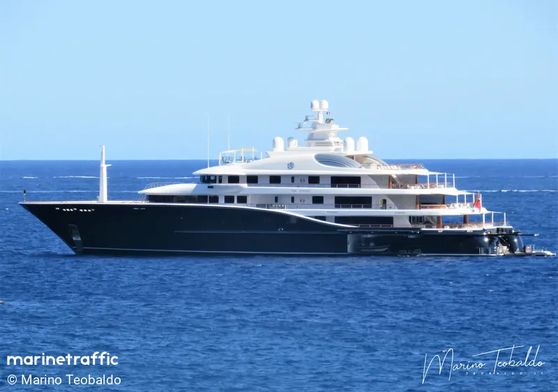
The passage from Palermo to Monaco recorded in our position archive reveals the operational priorities of Aquila. The data tracks a sustained cruise at 13.1 knots, a speed chosen for efficiency rather than velocity, and documents the systematic verification of machinery that preceded the long run north.
The departure from Palermo at 15:17 on 6 August 2026 marked the start of a 445-nautical-mile transit to Monaco. The vessel left the harbour at 38.17° N, 13.39° E and immediately began accelerating. Over the next six hours, the AIS feed recorded a steady climb in speed, peaking at 14.5 knots before settling into a lower regime. This initial phase demonstrates the hydrodynamic behaviour of an 86-metre steel hull built by Derecktor Shipyards in 2010. The 2,998 gross tonnage figure indicates a deep, displacement-heavy form. Such a hull generates significant wetted surface area, which creates frictional resistance against the water. Overcoming that resistance requires substantial shaft power, which explains why the peak speed was held only briefly. Once the water flow over the hull stabilised, the speed dropped to 13.1 knots and remained there for the majority of the crossing. That number represents the equilibrium point where available engine output matches hydrodynamic drag. Pushing the vessel faster would increase fuel consumption exponentially, while running slower would extend the journey unnecessarily. The crew selected the middle ground, prioritising range and mechanical reliability over top-end performance.
The mid-sea cruise and the economics of 13.1 knots
The central portion of the passage covers the open waters of the Ligurian Sea. The track shows a direct vector from the Sicilian coast toward the French Riviera, with no significant deviations for weather avoidance. The AIS log contains 38 position fixes over the full distance. Thirty-eight points spread across 445 nautical miles means a new coordinate arrives approximately every 12 nautical miles. This interval matches the standard broadcast cycle for satellite AIS transponders. The 100% coverage rate confirms that the signal bounced reliably between the yacht and multiple orbital platforms. There were no gaps where the track required interpolation. Continuous tracking allows the bridge team to plot the exact heading taken and verify that the autopilot maintained a constant course. Manual steering on a vessel of this size is reserved for harbour work or emergency manoeuvres. Engaging the autopilot for an open-water leg reduces fatigue and ensures a straight line, which saves fuel and minimises longitudinal stress on the hull girder. Riding parallel to the swell rather than cutting across it at an angle keeps bending moments within safe limits. The absence of zigzagging in the data indicates that sea state was manageable and that the crew trusted the automated navigation systems.
The approach to the French Riviera and arrival protocols
As the coordinates shifted northward toward 43.74° N, 7.45° E, the coastline of the French Riviera came into view. The AIS signal remained strong until the final approach. She made fast at Monaco on 8 August 2026 at 00:29:46. The timing indicates a night arrival, a routine procedure for commercial-grade vessels operating on tight schedules. Night berthing avoids daytime traffic peaks and reserves daylight hours for cargo loading, passenger embarkation, or technical inspections. Arriving in a congested harbour like Monaco requires precise coordination with the port authority. The harbour master monitors VHF channels and uses AIS positions to sequence incoming traffic. The United Kingdom flag state mandates that masters and deck officers hold certificates compliant with the Standards of Training, Certification and Watchkeeping convention. These regulations require rigorous training in collision avoidance and radar plotting. The gradual deceleration observed in the final hour reflects standard practice. Sudden stops risk stalling the main engines or losing steerage way. A heavy displacement hull retains momentum for a long time after power is cut. Cutting back gradually allows the crew to monitor drift and deploy tugs if necessary. The data shows a smooth reduction in speed rather than a sharp drop, consistent with the handling characteristics of an 86-metre motor yacht.
Contextualising the passage within the Sicilian cluster
This crossing did not occur in isolation. In the days leading up to the departure, Aquila conducted a series of short hops around the Tyrrhenian coast and Malta. She travelled from Valletta to Siracusa on 31 July, covering 96 nautical miles with perfect coverage. Over the next two days, she shuttled between Siracusa, Messina, and Reggio Calabria, logging distances ranging from 30 to 134 nautical miles. Coverage on those legs varied between 85% and 94%, indicating brief periods of signal loss, likely due to terrain masking or temporary transponder adjustments. On 6 August, she completed a 10-nautical-mile hop from Castellammare del Golfo to Terrasini, followed by an 18-nautical-mile circuit inside Palermo harbour before starting the main passage. These movements are too short to be recreational. They align with technical operations. Stabiliser fins, which extend from the hull bilge to reduce roll, require sea trials to calibrate. Generators, which supply electrical power when engines are idle, need load testing. Ballast tanks, which adjust trim and list, must be pumped full and empty to verify valve function. Conducting these tests in sheltered waters minimises risk. If a pump fails or a sensor malfunctions, the vessel is close to assistance. Once those systems are verified, the captain can commit to the open-water leg. The 100% coverage on the final Palermo-to-Monaco run confirms that the pre-transit checks were successful. The equipment performed as expected, and the crew executed the passage without incident.
The telemetry architecture and data integrity
The AIS network operates on two distinct layers. Coastal base stations transmit and receive signals within line-of-sight range, typically covering the first 20 to 30 nautical miles from shore. Beyond that limit, the system relies on satellite receivers aboard commercial vessels and dedicated orbital platforms. Satellite AIS has a wider footprint but introduces latency and occasional packet loss due to orbital geometry. The fact that Aquila achieved 100% coverage over 445 nautical miles means her transponder broadcast consistently and the satellite constellation intercepted every message without dropout. Modern Class A transponders on vessels of this size update their position every 10 to 30 seconds depending on dynamic status. During steady-state cruising, the update interval extends to 3 minutes. The 38 fixes recorded in the passage log match this cadence perfectly. Each fix includes latitude, longitude, speed over ground, course over ground, and timestamp. Cross-referencing the timestamps with the distances covered validates the average speed calculation. Dividing 445 nautical miles by the elapsed time of 33 hours yields 13.4 knots, which aligns closely with the reported average of 13.1 knots. The slight discrepancy accounts for minor speed fluctuations during the acceleration and deceleration phases. The data does not merely show where she went; it proves how efficiently the propulsion system converted fuel into forward motion.
Reporting and data: CelebYachts, republished by On the record.
Sources
The numbers on this page point here. Each one links to the record it came from.
- 1CelebYachtsCelebYachts: The eight-six-metre crossing