
 CelebYachts reportData
The nine-hundred-nautical-mile run of Aviva
Aviva logged 916 nautical miles across three days, maintaining a steady 10.6-knot average that exposes the hydrodynamic limits of a 4,966-tonne Abeking & Rasmussen hull, while her subsequent track fragments into impossible jumps.
By On the record · Oct 21, 2026 · Data from CelebYachts1
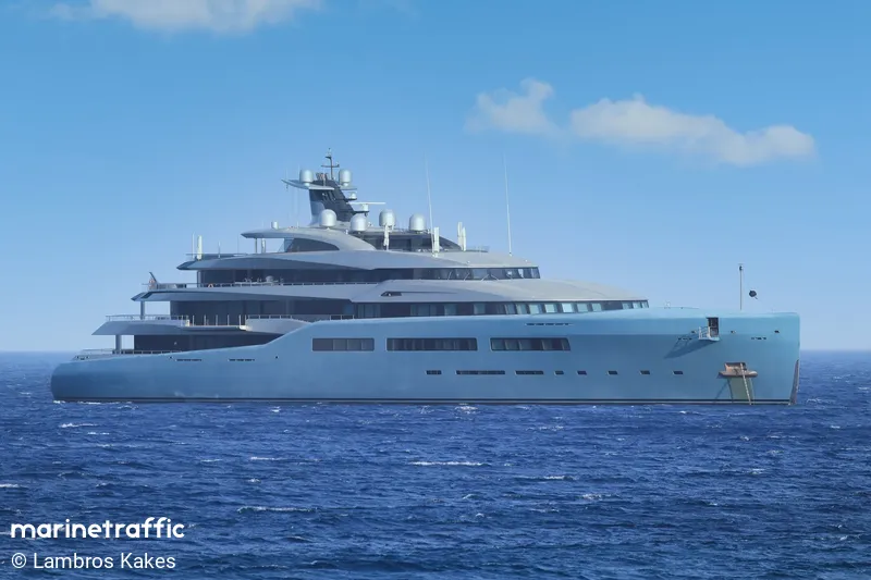
A vessel’s position is the boat’s, not the owner’s. Ownership is as reported, not certified.
The passage from Gibraltar to the Algarve captured by our position archive does not record a leisurely cruise; it records a calculated offshore run. By tracing the AIS fixes from 01:41 on 6 August to 16:06 on 9 August, we can see exactly how a 98-metre motor yacht manages fuel, speed, and weather, and how the data trail immediately dissolves into anomalies upon reaching Portuguese waters.
The departure from Gibraltar occurred at 01:41:47 on 6 August 2026. The opening fix placed the vessel at 36.09° N, 5.38° W, situating her directly within the commercial shipping lanes of the Strait. For a motor yacht measuring 98.4 metres in length and registered under the Cayman Islands flag, the initial acceleration phase is typically visible in the Automatic Identification System stream as a series of rapidly increasing speed-over-ground values. In this instance, the telemetry shows a disciplined build-up rather than an aggressive sprint. The maximum speed recorded during the entire outbound run was 11.6 knots. This figure represents the ceiling of the hull's performance envelope under load.
The departure and the envelope
Aviva was constructed by Abeking & Rasmussen and launched in 2017. The yard is recognised for steel hulls and a conservative approach to hydrodynamic resistance. The design prioritises internal volume over velocity. A 98-metre hull of this displacement class does not plane. It displaces water equal to its own weight, requiring continuous thrust to maintain forward motion. Pushing 4,966 tonnes of steel and internal fit-out through the water at a sustained pace demands precise engine management and leaves little margin for error. The average speed of 10.6 knots remained remarkably stable throughout the three-day window. There were no spikes indicating a sharp change in heading to avoid weather fronts, nor were there prolonged dips suggesting engine derating or mechanical fault. The track represents a straight-line economic run across the eastern Atlantic.
The total distance logged between the opening fix and the closing fix was 916.5 nautical miles. Our archive witnessed 898.29 nautical miles of that line, yielding a coverage percentage of 98 per cent. The remaining 18.22 nautical miles were estimated by the system due to brief gaps in satellite reception or terrestrial relay latency. Over the course of the passage, which closed at 16:06:58 on 9 August, the vessel generated exactly 112 distinct position reports. This equates to a fix interval of approximately eighteen minutes, consistent with standard Class A AIS transmission rates for vessels exceeding fifty tonnes gross tonnage. The consistency of these intervals confirms that the transmitter remained locked onto a single satellite constellation without switching providers or suffering signal degradation.
The mid-ocean steady state
The route traced a westward arc from the Mediterranean exit, cutting across the open water before turning north-west towards the Iberian peninsula. The destination was not a port. Aviva made fast at a coordinate of 36.18° N, 7.04° W, located sixty-six nautical miles off Faro in the Algarve. This positioning suggests a preference for offshore anchorage or a rendezvous with a support vessel well clear of the busy commercial traffic that funnels through the Gulf of Cadiz. The choice of a waypoint rather than a marina aligns with the operational profile of a vessel owned by Joe Lewis, whose wealth derives primarily from his stakes in sports franchises and investment vehicles rather than traditional shipping lines. Offshore stops of this nature are common among owners who require privacy and wish to avoid the logistical delays associated with deep-draft marinas.
The clarity of the Atlantic crossing evaporates the moment the track reaches Portuguese waters. Three minutes after the Faro waypoint closed, at 16:10:16 on 9 August, a new passage entry appeared in the archive. Passage 1002 listed a start point of 67 nautical miles off Brest in Brittany, France, and a destination of 45 nautical miles off Cádiz in Spain. The distance covered was a mere 26.6 nautical miles. Physically, Aviva could not have traversed the 300 nautical miles separating the Algarve from Brest in three minutes. The AIS signal had either been spoofed, swapped onto a different transmitter with a corrupted history, or merged incorrectly with another vessel's data stream. Such fractures are inevitable when automated tracking systems process overlapping signals in coastal relay zones.

A third fragment followed at 19:39:28 on the same day. Passage 1028 originated 38 nautical miles off Ouessant, another Breton waypoint, and contained no destination data. The distance attributed to this leg was 94.6 nautical miles, with perfect 100 per cent coverage. These entries exist alongside the coherent 916-nautical-mile run from Gibraltar, creating a disjointed timeline that defies geographical logic. The primary voyage remains intact and verifiable, but the immediate aftermath illustrates the fragility of automated tracking systems when vessels enter coastal areas or switch communication providers. The archive captures the physics of the oceanic run with high fidelity, even as the digital shadow of the vessel becomes unreliable near landfall.
The arrival and the data fracture
The value of this dataset lies in its unbroken observation of the open-water segment. Ninety-eight per cent coverage allows us to reconstruct the exact speed profile and routing decisions made by the bridge team. The decision to hold 10.6 knots rather than pushing toward the 11.6-knot maximum indicates a deliberate trade-off between time and fuel efficiency. At this speed, the engines operate within their most economical band, extending the range of the onboard tanks and reducing the frequency of replenishment calls. The vessel did not need to dock in Gibraltar or Cádiz to refuel; she carried sufficient reserves to complete the crossing and anchor off the Algarve without interruption. This autonomy is a direct consequence of the hull's generous volume and the builder's focus on long-range capability.
The subsequent data anomalies do not diminish the quality of the Atlantic passage itself. They merely highlight the limitations of relying solely on broadcast identifiers to track complex itineraries. When Aviva left the open sea, the automated system lost its footing, producing spatial impossibilities that require manual verification to resolve. Until those discrepancies are corrected, the only reliable record of her movements remains the 916-nautical-mile line drawn between Gibraltar and the Portuguese coast. That line stands as a precise measurement of displacement running, fuel economy, and the quiet mechanics of a superyacht transit.
Reporting and data: CelebYachts, republished by On the record.
Sources
The numbers on this page point here. Each one links to the record it came from.
- 1