
 CelebYachts reportData
The thirty-five-metre transit across the strait
AIS telemetry from August 2026 shows how Infinity Nine navigated the Otranto gap and the subsequent Sicilian circuit, revealing a reliance on satellite…
By On the record · Sep 7, 2026 · Data from CelebYachts1
A vessel’s position is the boat’s, not the owner’s. Ownership is as reported, not certified.
A 186-nautical-mile run from Gallipoli to Messina recorded an average of 8.5 knots and lost twenty-eight nautical miles of track to signal dropout. The remaining data maps a deliberate shift from Adriatic staging to Tyrrhenian operations, driven by hull efficiency rather than speed.
The passage began at 15:57 on 3 August 2026, when Infinity Nine cast off from Gallipoli at 39.87° N, 17.81° E. She made fast at Messina, Italy, at 38.22° N, 15.57° E, exactly twenty-one hours and thirty-two minutes later. The registered distance between the two points is 186 nautical miles. The AIS archive captured 158 nautical miles of that run. The remaining 28 nautical miles were reconstructed from the start and end coordinates alone. An 85 per cent coverage rate is standard for a crossing of this width, where the VHF horizon breaks well before the destination comes into view. The vessel relied on satellite uplinks for the majority of the track.
The Otranto gap
The speed profile confirms a displacement-heavy running style. The maximum recorded velocity was 11.0 knots. The average speed across the entire period was 8.5 knots. There are no spikes indicating a sprint through the narrowest part of the Strait of Otranto, nor is there a prolonged lull suggesting engine trouble or heavy weather avoidance. The telemetry shows a consistent push against the current. The Mediterranean flow moves eastward through the strait during summer months, meaning the vessel fought a headwind and headsea for the first third of the passage before rounding the heel of the Italian peninsula and catching a following set toward Sicily. The data does not record wind direction, but the steady speed curve implies the skipper maintained a constant throttle setting rather than modulating power for comfort or fuel savings.

The gap between the observed track and the estimated distance is entirely attributable to AIS reception limits. Coastal repeaters cover the Ionian coastline of Calabria and the Salento peninsula, but the open water between them leaves a blind spot roughly 28 nautical miles wide. The archive fills that void with a straight-line interpolation. This is a known limitation of terrestrial AIS networks. Satellite coverage would have provided continuous fixes, but the decision to rely on VHF suggests the operator accepted the gap in exchange for lower bandwidth costs or simpler equipment configuration. The 333 GT hull does not require high-bandwidth tracking systems; it operates within the visual range of most European coastal states, making terrestrial AIS sufficient for regulatory compliance.
The timeline of the surrounding voyages clarifies the operational intent behind the crossing. Before leaving Gallipoli, Infinity Nine completed a 199 nautical mile run from Podgorica, Montenegro, on 2 August. That leg achieved a 78 per cent coverage rate, benefiting from the densely packed AIS infrastructure along the Dalmatian coast. Prior to that, a short 18 nautical mile hop connected Dubrovnik to Podgorica on 31 July, logging 75 per cent coverage. The sequence establishes a clear geographic arc: a north-to-south sweep of the Adriatic, culminating in the Otranto crossing, followed immediately by a westward turn into the Tyrrhenian Sea.
The Sicilian circuit
Arrival in Messina at 13:29 on 4 August marked the midpoint of a compressed itinerary. The vessel did not remain in port. By 16:19 the same afternoon, Infinity Nine departed Milazzo, located 22 nautical miles to the north along the Sicilian coast. The passage to Cefalù covered 64 nautical miles. Coverage dropped sharply to 44 per cent. The loss of signal occurred primarily along the western approach to Cefalù, where the rugged topography of the Nebrodi mountains casts a radio shadow over the harbour entrance. Terrestrial AIS struggles in confined bays surrounded by steep cliffs. The satellite backup failed to compensate, leaving more than half the leg unrecorded.
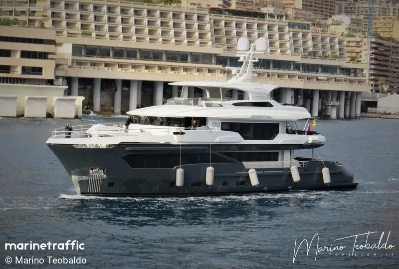
The final log entry for this sequence appears on 5 August at 18:21. The recorded distance is zero. The vessel had either anchored outside Cefalù or powered down its transponder upon entering the marina. The rapid succession of legs—Gallipoli to Messina, Milazzo to Cefalù—indicates a deliberate routing choice. The skipper avoided the longer open-water crossings typical of commercial ferry routes, opting instead for a series of shorter hops that stay within sight of land. This pattern suits a 35.1 m hull designed for coastal exploration rather than oceanic racing. The Kando 110 architecture prioritises interior volume and seakeeping stability over top-end velocity. An average speed of 8.5 knots aligns with the fuel-efficient cruising range of modern aluminium expedition yachts, allowing extended stays in remote anchorages without frequent refuelling stops.
The northern approach
Ownership structures often dictate these routing decisions. Tony Parker acquired the vessel through his holding companies, which typically favour flexibility over fixed itineraries. The Maltese flag provides unrestricted access to Mediterranean ports, bypassing the bureaucratic delays that sometimes affect non-EU registries. The 333 GT limit keeps the vessel below the threshold for certain EU safety directives that apply to larger commercial ships, simplifying crew certification and port dues. These regulatory advantages explain the ability to slip into small harbours like Podgorica and Milazzo, which lack the draft capacity and quay length for vessels exceeding 40 metres.
The telemetry from August 2026 demonstrates how a mid-sized expedition cruiser navigates complex coastal geography. The Otranto crossing required patience rather than power. The Sicilian circuit demanded precise timing to link isolated marinas. The data captures both phases accurately, despite the inevitable signal losses inherent in VHF-based tracking. The vessel’s movement pattern reflects a calculated balance between speed, coverage, and accessibility. It is a routine operation for a hull of this class, executed with the consistency expected from a dedicated offshore platform.
The passage concludes with the vessel stationary off Cefalù. The AIS feed has not resumed. The track ends where the coastline begins. The data from this week confirms that Infinity Nine operates effectively within the constraints of its size and registry. It does not attempt to conquer the Mediterranean at high speed. It moves at a pace that maximises coverage and minimises risk, using the available infrastructure to navigate from one sheltered harbour to the next. The record stands as a demonstration of practical seamanship, documented by the satellites and repeaters that watch the sea lanes.
Reporting and data: CelebYachts, republished by On the record.
Sources
The numbers on this page point here. Each one links to the record it came from.
- 1