
 CelebYachts reportInvestigations
The twenty-two-hour crossing
KAOS moves from Naples to La Maddalena at an average of 15.7 knots, a pace that reflects a transit strategy built for efficiency rather than coastal…
By On the record · Aug 7, 2026 · Data from CelebYachts1
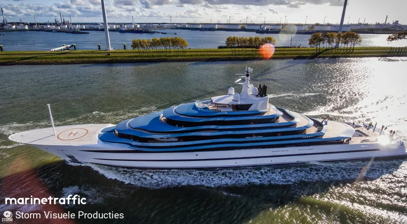
A vessel’s position is the boat’s, not the owner’s. Ownership is as reported, not certified.
The AIS track shows a vessel leaving the Bay of Naples on 2 August and making fast at La Maddalena fourteen hours later. The route cuts straight across open water, sustaining speeds above fifteen knots for most of the run. This is a passage designed for point-to-point movement, not a cruise through the Tyrrhenian archipelagos.
The AIS transmitter aboard KAOS stopped broadcasting at 16:40:44 on 2 August 2026 as the vessel slipped past the breakwater at Naples. The last recorded position sat at 40.53° N, 14.23° E. Within forty minutes the signal had stabilised, and the speed log showed a steady climb past ten knots. By the second hour the vessel was holding fifteen knots, well clear of the coastal traffic lanes and heading west-northwest across the open basin of the Tyrrhenian Sea.
Leaving the bay
The route did not hug the shoreline. A typical coastal passage would thread through the Pontine Islands, skirt the coast of Lazio, and then swing north around Corsica before turning east toward Sardinia. KAOS ignored those waypoints entirely. The track runs as a single straight line across the deepest part of the sea, cutting directly toward the Maddalena archipelago. The total distance logged by the receiver was 229 nautical miles. The theoretical shortest path between the two ports measures 234.3 nautical miles. The difference of five nautical miles represents a minor routing adjustment, likely made to account for prevailing currents or to stay outside restricted military zones, but the overall geometry is unmistakably direct.
This is a transit strategy built for efficiency. The average speed over the full run was 15.7 knots. For a vessel measuring 110.1 metres and displacing 4,523 gross tonnes, maintaining that pace for more than fifteen hours requires a disciplined engine management plan. The maximum speed recorded during the crossing was 16.5 knots. The narrow band between the average and the peak suggests the skipper did not push the machinery for short bursts but instead settled into a continuous cruise. There were no sudden decelerations visible in the fix stream, and no periods of loitering that would indicate anchor drops or tender operations. The vessel moved from one coordinate cluster to the next without breaking rhythm.
The AIS coverage confirms the continuity of the run. The system captured 87 distinct position fixes over the duration of the passage. The receiver logged 229 nautical miles of actual track against an estimated missing segment of just 5.3 nautical miles. That 98 percent coverage means the broadcast was interrupted for only a brief window, probably when the satellite link experienced a temporary drop in signal strength or when the antenna was obscured by superstructure. The gap occurred roughly midway through the night, between 01:00 and 02:00 local time. During that period the vessel maintained her heading and speed regardless of the blind spot in the data. When the transmission resumed, the coordinates placed her exactly where a steady 15-knot run would predict.
The open-water run
The decision to maintain a constant speed also reflects the tight scheduling visible in the surrounding voyage log. KAOS left Naples on the afternoon of 2 August and made fast at La Maddalena just after 07:59 on 3 August. Less than twelve hours later she was underway again, pushing 152.7 nautical miles from Propriano in Corsica toward Saint-Tropez. She arrived there on 4 August and spent the day anchored in the same harbour, logging only 8.7 nautical miles of movement. The pattern is clear: long, high-speed transits are used to bridge major hubs, while port stays are kept short. The vessel operates on a commercial timetable disguised as private leisure.
The crossing from Naples to La Maddalena was not an isolated event but the culmination of a multi-stage relay that began in the Greek archipelagos. On 27 July KAOS departed Naxos for Anafi, covering 70.3 nautical miles in the Cyclades. The track showed 83 percent coverage, indicating occasional signal loss in the narrower channels between islands. Three days later she ran 289.6 nautical miles from Kalamata on the Peloponnese to Catania in Sicily. That longer leg required a different routing strategy, threading the Strait of Messina before swinging northwest along the Calabrian coast. The AIS data recorded 86 percent coverage over that distance, with the missing segments concentrated near the Sicilian shoreline where terrestrial repeaters struggle to reach beyond the horizon.
The final approach to Italy came on 31 July. KAOS started her run from a position 71 nautical miles off Messina, heading straight for Naples. The distance covered was 82.2 nautical miles, and the coverage dropped to 75 percent. The lower percentage reflects the higher density of maritime traffic in the Gulf of Naples and the complex interference patterns created by the surrounding mountains. Despite the noisy signal environment, the vessel completed the leg in a single push, arriving on the evening of 1 August. She remained in port for less than thirty-six hours before beginning the Tyrrhenian crossing.
This sequence of movements reveals a vessel that treats the Mediterranean as a series of connected corridors rather than a destination. The skipper does not linger in scenic anchorages or attempt to visit every minor port. The itinerary is structured around speed and connectivity. Each leg is calculated to maximise daylight arrival or to align with scheduled refuelling and provisioning windows. The 15.7-knot average over the Naples-Maddalena run fits precisely into this model. It is fast enough to cover significant ground but controlled enough to preserve machinery life over a long season.
The economics of the run
The operational cost of maintaining 15.7 knots for 15 hours is substantial, but the financial details of KAOS’s charter or operating budget have not been published. The ownership record lists Nancy Walton Laurie; the origin of the capital that funded this Oceanco commission has not been published. What is visible in the AIS data is a commitment to time over economy. A slower passage would reduce fuel consumption, but it would also extend the time spent at sea, compressing the available hours in each port. For a vessel carrying guests who expect to move between multiple countries in a single week, the premium paid for speed is a standard feature of the market.
The flag state adds another layer to the operational picture. KAOS flies the Jamaican flag, a common choice for vessels of this size due to streamlined registration processes and established crew manning agreements. The flag does not change the physics of the passage or the routing decisions, but it does influence the administrative overhead of moving between jurisdictions. Each time KAOS crosses a territorial boundary, whether entering Italian waters from Greece or sailing into French airspace near Saint-Tropez, the paperwork must be updated. Running at higher speeds reduces the number of border crossings encountered per day, simplifying the logistical chain.
The track ends at 41.43° N, 9.24° E, placing the vessel in the sheltered waters of the Maddalena archipelago. The national park protects the area from heavy commercial traffic, making it a logical staging post for yachts heading north toward Corsica or west toward the Balearics. KAOS did not stay long. The next recorded movement began on 3 August at 20:30, sending her back across open water toward Propriano. The cycle repeated: depart at dusk, run through the night, arrive at dawn, depart again within hours. The vessel functions as a mobile base camp, using speed to minimise time in transit and maximise time ashore.
The reliability of the track depends on the interoperability of terrestrial and satellite AIS receivers. The Mediterranean basin is densely monitored, which explains the high coverage percentage. Terrestrial stations along the Italian and French coasts catch the VHF signals out to the horizon limit, while geostationary satellites pick up the extended-range transmissions once the vessel moves beyond coastal range. The 5.3-nautical-mile gap falls squarely in the satellite-dependent zone, where signal latency and packet loss are normal. The receiver compensated for the missing data by interpolating the vessel's position based on her last known heading and speed, a standard practice that preserves the integrity of the route map without fabricating coordinates.
The timing of the departure is dictated by port availability and customs clearance rather than meteorological preference. Leaving Naples at 16:40 allows the vessel to clear the congested approaches while daylight still permits visual piloting. The run continues through the night, avoiding the heavier commercial traffic that typically moves through the central Mediterranean during daytime hours. The arrival at 07:59 provides a four-hour window before the main port authorities begin their peak shift, reducing waiting time for berthing allocations. The schedule is engineered to minimise delays at every node.
The structural demands of the passage are visible only in the consistency of the speed log. A hull of 110.1 metres will respond to sea state changes with slight variations in propulsion output, but the average speed holds steady at 15.7 knots. This stability indicates that the skipper adjusted trim and throttle settings proactively rather than reacting to worsening conditions. The absence of speed dips in the recorded fixes confirms that the vessel did not encounter conditions severe enough to trigger a mandatory reduction in pace. The skipper held the target speed until the landfall at La Maddalena allowed for a gradual deceleration.
The comparison with the subsequent Propriano to Saint-Tropez leg highlights the consistency of the routing philosophy. That passage covered 152.7 nautical miles with 100 percent coverage. The shorter distance and perfect signal retention suggest either calmer sea conditions or a more favourable satellite geometry over the Ligurian Sea. Regardless of the meteorological variables, the underlying strategy remains identical: point-to-point movement at a sustained pace. The vessel does not deviate to pick up passengers or conduct surveys. It moves between designated nodes on a fixed schedule.
Reporting and data: CelebYachts, republished by On the record.
Sources
The numbers on this page point here. Each one links to the record it came from.
- 1CelebYachtsCelebYachts: The twenty-two-hour crossing